A Sovereign Ordinance* was published in the Journal de Monaco on 20 April 2018 regulating four zones to secure the maritime area around the offshore Anse du Portier seafront extension project:
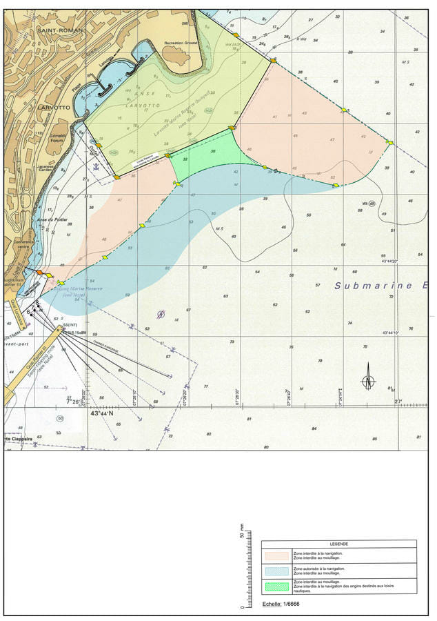
- Two maritime zones (in pink on the attached map) are work areas prohibited from public access and all maritime activities. Navigation, anchoring and fishing are strictly forbidden. They are defined by yellow buoys.
-The first extends from the protected marine area of the Spélugues, to the West, to the protected marine area of Larvotto, to the East.
-The second stretches out to the Larvotto marine area at the eastern sea border of the Principality.

- A marine zone prohibits the anchoring and navigation of water-based recreational vehicles (such as sailboats, jet skis, oars, etc.) located between the two preceding zones (in green on the map).
- A maritime zone prohibiting anchoring along the previous zones (in blue on the map).
This regulation will come into effect from Tuesday 1 May 2018 until the end of the construction of the marine infrastructure planned for 2020.
For more information: Directorate of Maritime Affairs – (+377) 98 98 22 80
* Sovereign Ordinance No. 6.885 from 11 April 2018 regulating the navigation, anchoring, fishing, underwater fishing, the practice of swimming and water sports and scuba diving in the area of the urbanization at sea construction works.


